Wednesday, July 3, 2024

Happy Fourth of July – and please celebrate responsibly

Every summer, the Fourth of July brings air quality concerns. Smoke from fireworks is composed of particle pollution and toxic compounds, and air quality monitoring sites in Washington tend to register above-average values on the Air Quality Index (AQI) during and following Independence Day celebrations. These elevated AQI values generally persist into the early morning hours of July 5 but can linger longer if atmospheric conditions trap the pollution near the surface. The air pollution generated by these events impacts wildlife, the environment, and people – especially those in sensitive groups.

So, many communities in Washington can expect air quality to diminish the night of the 4th into the morning of the 5th, especially in urban areas with lots of fireworks. The Puget Sound Clean Air Agency has already set their AQI forecast to “moderate” for this time.

Across the state, fireworks are prohibited in most urban areas. This includes Seattle, Tacoma, Olympia, Yakima, Spokane, and Bellingham. If you’re not sure what’s allowed where you live, contact your local fire department. As they like to say at the Department of Natural Resources: don’t set the state on fire. 

National Weather Service (NWS) forecast

Today (July 3), there is a small chance of thunderstorms and lightning in northeast Washington and northern Idaho. This means new fires could start in that region. Starting Thursday (July 4), conditions will be dry and temperatures hot throughout the state. Afternoon highs will be 10-15 degrees above normal and an excessive heat warning has been issued for central and eastern Washington. See the graphic below from the National Weather Service (Spokane) for more details. 

NWS Caption: "Our first significant heat wave of the season will develop this weekend and persist well into next week. The early to middle part of next week has the potential to threaten records with moderate to major values of Heat Risk. Hot and dry weather will also lead to increasing fire danger as our landscape becomes increasingly dry."


Fireworks and wildfires

Humans are responsible for starting at least 85% of all wildfires. And we start more wildfires on July 4 than on any other day of the year. Between 1992 and 2015, more than 7,000 wildfires were sparked nationwide on this date alone. Given the state’s current drought conditions, we encourage everyone to consider attending a public fireworks display rather than lighting fireworks at home, where injuries and accidental fires are more likely to occur. 

Wildfire season is here

Wildfires have already begun across Washington. A few communities have seen evacuations and poor air quality. As we move deeper into this year’s wildfire season, please ensure you know how to protect yourself and those around you. This means:

Monday, June 17, 2024

WA wildfire update: Pioneer Fire continues to impact Lake Chelan

The Pioneer Fire continues to burn in the Lake Chelan-Sawtooth Wilderness near the north shore of Lake Chelan. Unfortunately, this fire will likely be a long term event; people in the area should expect intermittent air quality impacts as the fire spreads. The map at the top of this page now shows a box around the fire location--this box indicates that there is now a daily smoke outlook issued by an Air Resource Advisor for the Pioneer Fire. Clicking on the link in the box will take you to the smoke outlook, or it's accessible by clicking on the Local Smoke Outlooks tab on the blog.

Over the weekend high winds led to the fire doubling in size as well as variable smoke impacts in the area. The Chelan area saw mostly moderate smoke impacts, but areas east of Lake Chelan in the Methow observed unhealthy and worse air quality impacts on the evening of June 15:


Winds pushing smoke to the southeast today will cause moderate air quality impacts in Chelan and Manson. Breezier winds tomorrow and warming temperatures will increase fire growth and lead to air quality index values ranging from moderate to Unhealthy for Sensitive Groups.

Across the region, the Beam Road Fire east of Zillah is 42% contained; evacuations have been reduced and air quality impacts have been minimal. After causing moderate smoke impacts in the Lewiston-Clarkston area last Friday, the Nisqually John Fire is now 100% contained.

As always, keep an eye on air quality conditions and the smoke forecast, and we'll update the smokeblog as needed. 

Wednesday, June 12, 2024

Active wildfires in Central WA

Warm weather, dry conditions, and breezy winds increase fire danger. We've observed these conditions recently across the state and a few wildfires have popped up in Central Washington (note that these wildfires were not ignited by lightning). A few recently ignited fires of note: 

The Pioneer Fire burning on the north shore of Lake Chelan is causing intermittent smoke impacts in the Chelan area and south of Twisp, with Air Quality Index values reaching moderate and unhealthy for sensitive groups. The fire has grown to 672 acres (6/13 update: 1468 acres; Chelan County evacuation information) and is currently 0% contained. The intermittent smoke impacts will likely continue through at least this week. A cold front arriving on Friday will bring breezy southwesterly winds, cooler temperatures, and a slight chance of precipitation over the weekend. The cooler temperatures and slight chance of rain should dampen any fire growth.


Pioneer Fire from the air. Source: WA DNR

The Finley warehouse fire continues to burn; near-real time air quality conditions from recently installed sensors in the area can be seen at the map at the top of this page.

A few other fires (such as the Marsh Fire outside of Yakima and the Palisades Road Fire west of Quincy) no longer have active evacuations and air quality impacts have been minimal.

Warm and breezy weather conditions are favorable for fire growth and spread; be sure to recreate responsibly and keep an eye on conditions.

Monday, June 10, 2024

Smoke Ready Week and 2024 Wildfire Outlook

Smoke Ready Week, June 10-14

Since wildfire season will be here soon, now is the perfect time to ensure you and those around you are prepared. Getting #SmokeReady—the focus of this week—means identifying personal health concerns, learning ways to protect your indoor air, and knowing where to find up-to-date information about wildfire smoke.

Over the course of #SmokeReadyWeek, WA Smoke Blog partners will be posting on social media in line with daily themes:

  • Monday, June 10: Learn about smoke
  • Tuesday, June 11: Stay informed about smoke
  • Wednesday, June 12: Smoke and your health
  • Thursday, June 13: Minimize exposure to smoke
  • Friday, June 14: Prevent smoke

Luckily, if you’re reading this, you already know about the WA Smoke Blog: the state’s leading public resource for wildfire smoke information. This site features a map with Air Quality Index (AQI) values from monitors and sensors that measure PM2.5 across the region. In addition to current air quality conditions, the map also shows a smoke forecast for the next five days. When using this tool, please remember to check the forecast regularly, as conditions can change very quickly.

Below the map, there are tabs for the latest smoke information, local smoke outlooks, and external resources. Here, you can find additional sources on monitoring, forecasting, and fires, and details about the health impacts of wildfire smoke. The Department of Health’s wildfire smoke page is an excellent place to go if you have any questions or concerns about keeping yourself safe this summer.

In the days and weeks to come, be sure to familiarize yourself with the resources listed here on the WA Smoke Blog. Preparing early reduces the stress of wildfire season, so please share this information to help others get #SmokeReady!

2024 Wildfire & Smoke Outlook

Wildfire smoke is a risk every year, but the extent to which it affects Washington residents depends on the severity of fire season throughout the Pacific Northwest. The brief overview for the season is that we are expecting a quick start to wildfire season and slightly more active season than normal across Washington and British Columbia. In contrast, the season could be less active than normal across Oregon and California, especially in the first half. With the enhanced local wildfire risk, smoke impacts are possible too, but small-scale details cannot be known in advance and will instead be updated in future blog posts. Continue reading for a more detailed discussion of the factors at play heading into fire season.

Drought & Precipitation: Some Areas of Improvement, Other Areas of Concern

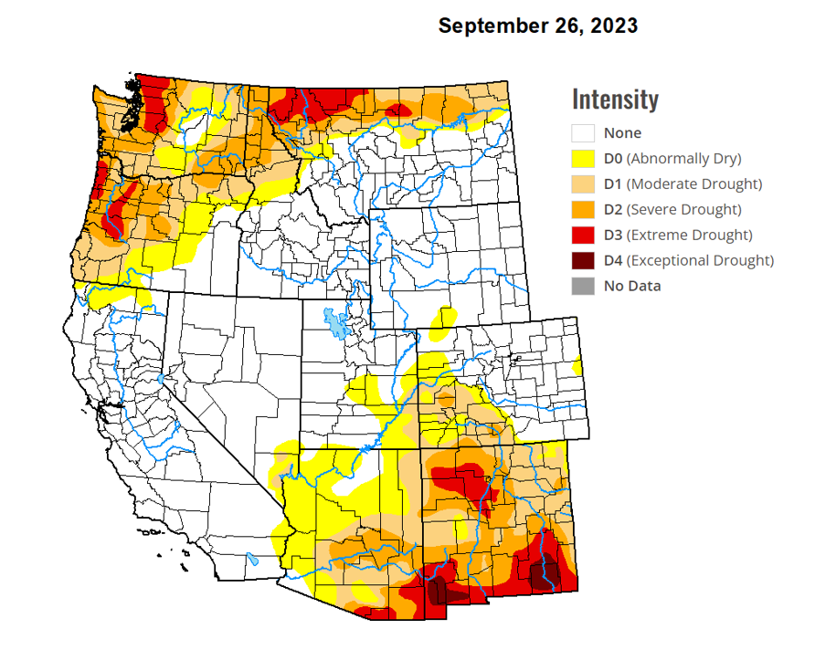
A contributing element to wildfire season is the level of drought across the region. Thinking back to last fall, much of the PNW was experiencing some level of drought. Here in Washington, the central and northern Cascades were particularly impacted, experiencing extreme drought at that time.
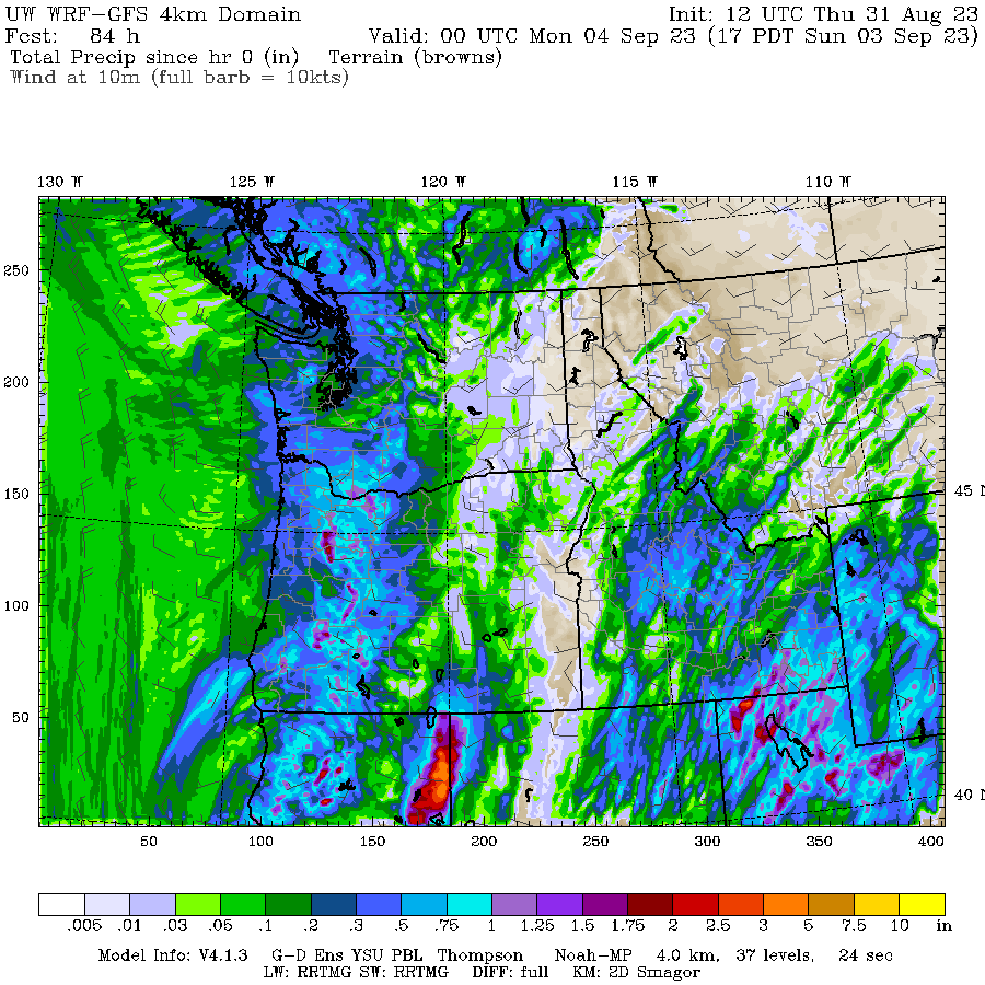
Drought map of the western U.S. in late September 2023. Courtesy droughtmonitor.unl.edu.

Since then, normal to above normal precipitation has alleviated drought in some areas, especially in Oregon where drought has essentially been eliminated completely heading into this summer. The situation in Washington is less optimal with most parts of the state remaining drier than normal over the last 5 months, especially the central/northern Cascades and Blue Mountains where precipitation has only been 50-70% of normal since January 1. As a result, these areas maintain moderate drought status heading into the summer. It’s worth noting that abnormal dryness also extends across the border into much of British Columbia.

Percent of average precipitation for the western U.S., January 1 to June 4, 2024. Courtesy the Western Regional Climate Center (WRCC).

Drought map of the western U.S. in early June 2024. Courtesy droughtmonitor.unl.edu.
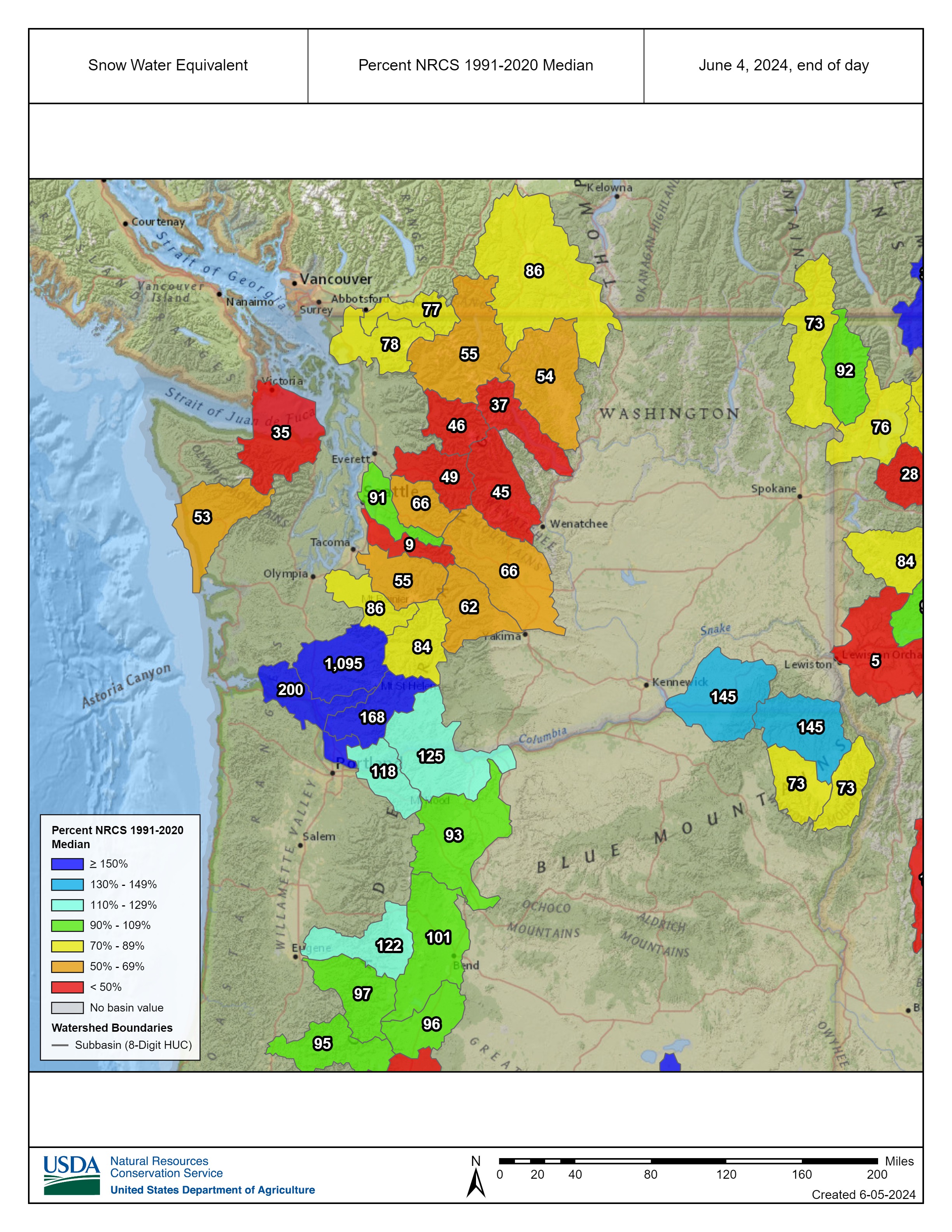
Snowpack

Snowpack is another important factor to consider when determining how early or late in the season that mid-high elevation forests will be available for burning. Above average snowpack will take longer to melt out and can often delay fire concerns until later in the season. With that in mind, there is a relatively lower than normal risk of fire during at least the first half of the season across the mountains of Oregon and California because of their near to above normal snowpack. In Washington however,  snowpack is generally poor heading into summer, especially across the central and northern Cascades where snow water equivalent (SWE) values are generally only 35-80%. As a result, many of Washington’s mid-high elevation forests will be snow-free at some point in June and could make fuels available to burn sooner than normal, especially if dry and warm weather persists for extended periods of time. Communities on the east slopes of the Cascades are a particular concern for this season because precipitation deficits are most significant in these areas. They have not received much of the beneficial precipitation that fell across much of Western Washington in recent weeks.
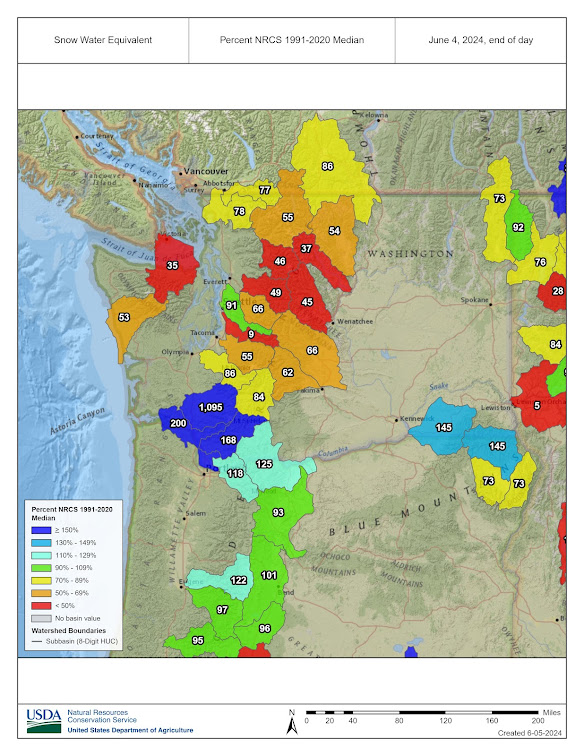
Snow water equivalent percentage across various watershed sub-basins in WA & OR on June 4, 2024. Courtesy the Natural Resources Conservation Service (NRCS).

Temperature Outlook


Seasonal temperature outlook valid July/August/September 2024. Courtesy the Climate Prediction Center (CPC).

From a temperature perspective, the highest risk for above normal temperatures will be over the desert southwest this summer. But much of the western U.S. is projected to see a warmer than normal July/August/September. Here in Washington, there is a 40-50% chance of above normal temperatures in Western Washington and a 50-60% chance of above normal temperatures in Eastern Washington. This basically means that we’re more likely to see a warm summer than a cold summer, and that’s especially true across eastern Washington. Still, a really hot summer is not guaranteed.

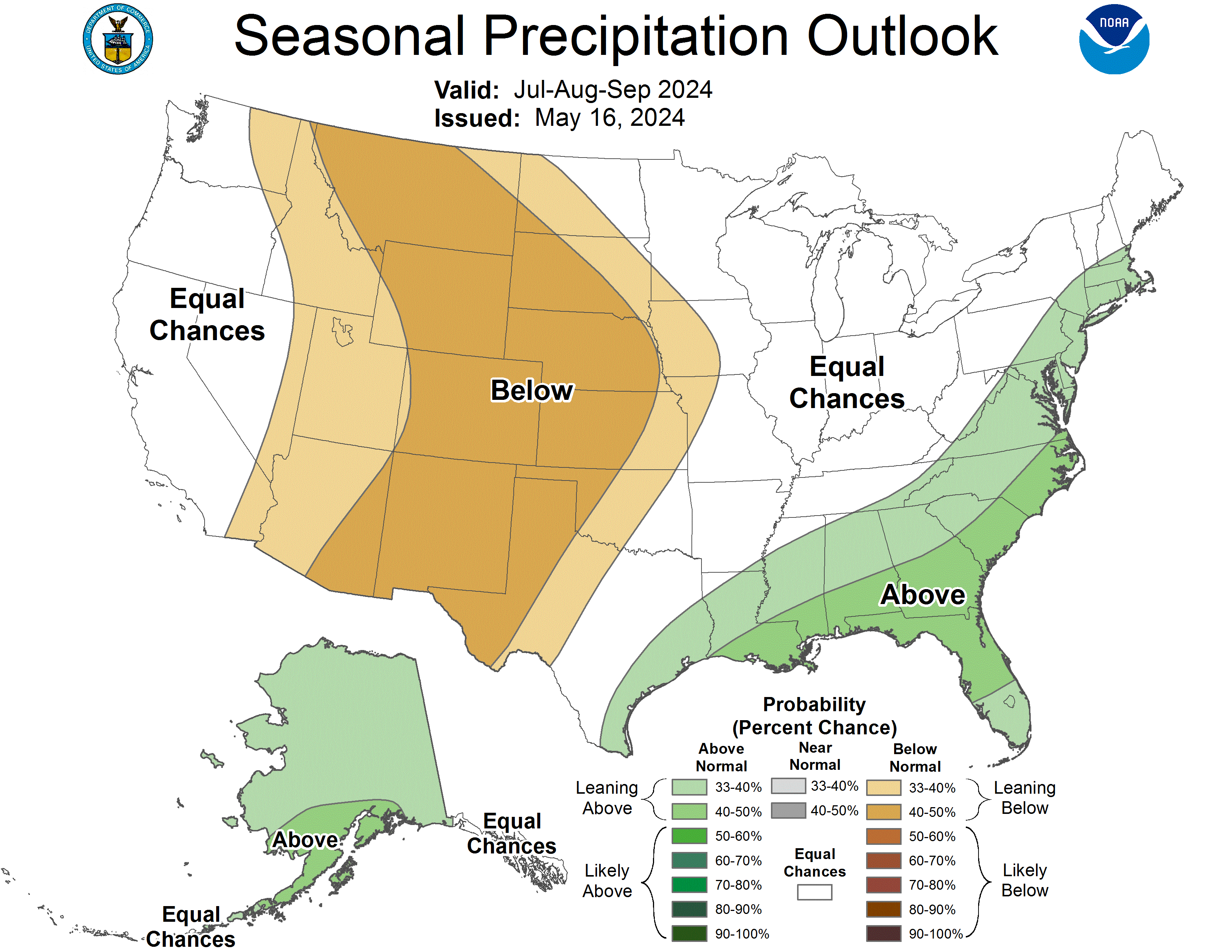
Precipitation Outlook


Seasonal precipitation outlook valid July/August/September 2024. Courtesy the Climate Prediction Center (CPC).

From a precipitation standpoint it’s important to note that summer in the Pacific Northwest is typically dry in a normal year. Fuels will become drier and increasingly available to burn over the summer even if some moisture makes it into the area from time to time. Speaking of which, long-term signals for July/August/September are mixed for how much precipitation will fall across the PNW, with most of Washington in a coin toss for above or below normal precipitation. Putting this into context, we might see some moisture cross the region, occasionally reducing fire danger, but there is no indication that seasonal wildfire risk will be stifled by consistent rain. 

Putting it All Together

In most of Washington and British Columbia, factors such as below average snowpack and likelihood of above normal temperatures suggest a quicker than normal start to fire season and a slightly more active season overall. In contrast, California and Oregon had good water years, likely keeping fire activity around normal or below normal during the first half of the season. 

The second half of the season looks a bit different. By August, warmer than normal temperatures should allow Oregon and California to begin ‘catching up’ in fire activity as heavier fuels finally dry out and become available to burn. Furthermore, lower-mid elevation areas in California have seen increased grass and shrub growth this year from a wet late winter and spring. These fuels will dry out over summer adding fuel loading for potential higher intensity late season fires. With these factors in mind and IF enough ignitions occur, we’re set up to see near to above normal wildfire activity across the west coast during the second half of fire season. It’s also worth noting that a developing La Nina may delay or reduce the late fall and early winter rains in California, potentially extending fire season later into October and November for that region. 

Outlook for significant wildland fire potential, July, August, September (left to right). Courtesy Predictive Services, National Interagency Fire Center (NIFC).

More to Come

While this outlook frames possibilities for the upcoming fire season, it is not possible at this time to make accurate predictions of wildfire locations, acreage burned, or air quality values. Even if conditions suggest high fire potential, wildfires don’t start without ignition sources (lightning or human-caused) and this can make a big difference in what kind of season we ultimately have. Additionally, short-term weather patterns play a critical role in determining fire spread, fire suppression possibilities, smoke production, and smoke transport across the region. That’s where the smoke blog comes in -- we’re here to provide information about wildfires and smoke every step of the way. Stay tuned for more updates as summer heats up! 

Monday, September 25, 2023

Residential wood smoke from home-heating on the rise

It's gotten cold out there!  Autumn is finally here and with that comes cooler weather and the need to heat homes.  Residential wood smoke from home-heating should be expected, especially at night and in the mornings when woodstoves and other wood-burning devices are regularly used.  Temperature inversions and light winds can cause smoke to stagnate, especially in valley communities.  This blog is intended to focus on wildfire smoke, but forecasts will be issued by Local Clean Air Agencies on their own sites and on AirNow.  As the season progresses, the National Weather Service may issue Air Stagnation Advisories and clean air agencies may initiate air quality burn-bans posted on their web pages, though we usually don't see those until November. 


Wednesday, September 20, 2023

Favorable Wildfire Smoke Outlook; Prescribed Fire Season Starting!

Recent rainfall and cooler temperatures limit smoke production on active wildfires

It certainly appears that wildfire season in Washington is winding down! A series of two cold fronts swept across the state on Monday and Tuesday, with the latter bringing cooler temperatures and rainfall to most areas of the state. As the westerly winds picked up ahead of the cold front on Tuesday, some individuals reported smelling smoke in the Seattle/Everett/Mt. Vernon corridor. This was likely a result of the still-smoldering fires in the Olympic Mountains, but air quality remained Good at all locations! 

Speaking of the fires in the Olympics, the Delabarre Fire has burned 3,658 acres as of September 19th, narrowly edging out the 2018 Maple Fire (3,273 acres) and the 2015 Paradise Fire (2,791 acres) to become the largest fire in the Olympic Mountains since the Great Forks Fire of 1951. Below is a map of all fire perimeters in the Olympic Mountains from 1951-2023, with the Delabarre Fire highlighted. Fortunately, the recent rainfall and cooler temperatures should limit any further growth of the incidents on the Olympic Peninsula. 


The other major smoke producer in Washington over the past month has been the Airplane Lake Fire, which has consistently funneled smoke into the Leavenworth/Wenatchee Valley. This fire also saw rain yesterday, though less than the Olympics. It is possible that with warmer weather on Thursday and Friday the Airplane Lake Fire may perk up a bit, but winds will be out of the east, providing the aforementioned areas with relief from the smoke. Some elevated smoke will likely be transported toward the Puget Sound, but I do not expect enough burning activity to produce any impacts above occasional MODERATE readings. 

Looking ahead to the weekend and early next week, I expect our first widespread heavy rain event to impact all areas along and west of the Cascades beginning Saturday and continuing through the first several days of next week. A true Washington Autumn classic, winds will be gusty and several periods of rain are expected. Below is the total precipitation forecast from NOAA's Weather Prediction Center through Wednesday morning, and you best believe this will tamp out any wildfire smoke concerns for the foreseeable future! Currently, the heaviest rainfall is expected on Monday and Tuesday. 


As wildfire season winds down, prescribed fire season picks up. Prescribed fires also produce smoke concerns, but the smoke is much shorter lived and burns are regulated to minimize air quality impacts across the state. The goal of prescribed fires is to promote a healthier, more wildfire resistant landscape, and are a very important tool in reducing wildfire danger to communities across Washington. If you live near US Forest Service or Washington DNR managed lands, follow your local USFS or DNR offices on social media to stay up to date on any planned burns in your area! 


Friday, September 15, 2023

Outlook: good air quality and localized smoke impacts

 The majority of the state continues to experience good air quality and low fire danger. A very clear satellite image from this morning--only the smoke plumes from the Airplane Lake Fire and agricultural burning in SE WA are visible, as well as smoke in Oregon):


The Airplane Lake Fire continues to cause intermittent smoke impacts around the Lake Wenatchee area and into the Wenatchee Valley, impacting the communities of Leavenworth, Cashmere, and Wenatchee. These intermittent smoke impacts will continue until the next significant precipitation event. There is potential for light smoke impacts today in East Snohomish County, but winds from the west this weekend will push any smoke east of the Cascades.

Across the rest of the state, fires in the Cowlitz Complex comprise almost 700 acres and are partially contained. Smoke from these fires is not expected to impact nearby communities. The Sourdough Fire continues to intermittently impact areas close to the fire in the Ross Lake National Recreation Area. There are also a few fires currently burning in the Olympics that were ignited two weeks ago by lightning strikes. Smoke from these fires (including the Eagle Point and Low Divide Fires) may intermittently impact Port Angeles and higher-elevation areas around Port Angeles. 

Weekend outlook: warm and dry conditions are forecasted for the weekend, but we're not expecting any significant new fire activity. Increased smoke from any local fires and prescribed burning may cause localized moderate air quality levels. Forecasted high winds across Central and Eastern Washington along with the dry conditions can lead to rapid fire spread; please continue to recreate responsibly.


-----------------------------------------------------------------------------------------------------------------------------

Taking a look back at our air quality this wildfire season, below is a plot of observed daily air quality levels for each day in each county in the state where there is an air quality monitor. Each row corresponds to the daily average at the most impacted monitor observed in each county on a given day. The major events we saw this wildfire season are highlighted--smoke from the Alberta fires in May, smoke from the Cascades and Southern BC fires in August as well as local fires in Spokane, and smoke from fireworks on the 4th of July. 


And how does this season compare to previous years? If we look at a timeseries of PM2.5 concentrations averaged across the state during wildfire seasons over the past 10 years, this year we saw smoke impacts in August, which is pretty typical. In previous years, easterly wind events have contributed to large smoke events in September and October. While it's only mid-September, that seems increasingly unlikely to occur this year, thanks to the recent cool temperatures and precipitation in the region and the low number of active fires in the Cascades.


Friday, September 8, 2023

Good air quality and low fire danger

Despite good air quality in most of the state, the Airplane Lake fire still has active hot-spots and is producing smoke that's been impacting residents around Lake Wenatchee.  Intermittent moderate smoke is also affecting the nearby communities of Entiat and Cashmere.  The Airplane Lake fire has only grown 200 acres over the past few days, but the fire is uncontained and will continue to produce smoke until the next wetting rains occur, which are not expected anytime soon.  

A wind shift is expected tonight, and moderate smoke from the Airplane Lake fire is expected to impact mountain towns in Snohomish County (such as Darrington) over the weekend.  That shouldn't last long though, as westerly winds are expected to pick back up on Sunday afternoon.

The Sourdough fire near the Ross Lake National Recreation Area is partly contained and has not grown much at all, prompting officials to reopen some trails and camps in the area.  Smoke from the fire has been minimal and intermittent, with no large hot-spots detected recently.

Other fires of note in Washington are in the Cowlitz Complex, with 700 acres burned across several fires.  Despite partial containment, there is still moderate fire behavior at the Snagtooth, Spencer Quartz, and Grassy Mountain fires.  No significant smoke has been detected in the area so far, but sensors are sparse in the region.

Fire danger remains too low for much risk of new significant fires in the coming days. The majority of our wildfire season has passed, and we don't expect any big flare-ups.   Since air quality and fire weather are not a concern, agricultural burning in the Columbia Basin and Idaho has begun.  Residents near agricultural communities from Yakima to Whitman county will likely see intermittent moderate smoke from agricultural burning through the month.

Smoke from the Airplane Lake Fire (image courtesy of 610KONA.com)


Thursday, August 31, 2023

Rain to the rescue: Smoke in Vancouver and the Weekend Outlook

Smoke from the Camp Creek Fire is funneling into the Vancouver area this morning. Air quality monitors in Vancouver observed elevated concentrations of PM2.5 starting around 3am. Air quality should improve today with the rain, but the pattern may repeat itself tomorrow morning. The Southwest Clean Air Agency has issued an Air Pollution Advisory for Clark County today through tomorrow afternoon due to intermittent unhealthy smoke impacts.


As for the upcoming weekend, recent rain has moderated smoke production from local fires, and more rain is coming thanks to a new frontal system. Colder temperatures and more moisture bode well for decreasing fire potential from any new lightning starts. Check out the forecasted total precipitation for the region through Sunday evening:


Forecasted winds from the north Friday and into Saturday will transport Canadian smoke down into Okanogan Valley. The area may observe intermittent moderate air quality. Smoke from the Airplane Lake Fire is also causing moderate to unhealthy air quality in the Lake Wenatchee area, which may continue through the weekend before more rain arrives on Sunday. Other than that, minimal smoke impacts are expected throughout the state this weekend. For areas close to fires, check out the smoke outlooks tab for updates. Enjoy the (mostly) good air quality!

Thursday, August 24, 2023

Regional haze dispersing, but several fires still causing local smoke impacts

Satellite imagery shows the remnant wildfire smoke haze dispersing this morning, but some fires are still producing visible smoke plumes.  We also expect easterly winds over the next few days and a Red Flag Warning is in effect for the West Cascade slopes of Lewis, Pierce, and King county due to dry and windy conditions.  With the expected wind shift, a moderate amount of BC smoke is expected to drift down into the Puget Sound region this weekend.  No Air Quality Alerts are planned at this time, but Moderate to USG smoke will likely impact northern counties for a couple days.

Residents in Okanogan have been living with intermittent smoke from nearby BC fires for quite some time, and that will continue.  The fires in British Columbia continue to dwarf what is going on in our state.  However, a low pressure system is expected to cause rain showers across the Pacific Northwest on Tuesday, and this should help limit temperatures and smoke production across the region.  BC officials also report that there has been good progress on containing fires and some evacuees are being allowed to return home.

The Airplane Lake fire (2,300 acres) in the Glacier Peak Wilderness Area of Chelan County has been pushing smoke into the Wenatchee region.  However, winds are shifting and Snohomish County communities like Darrington and Gold Bar will probably smell smoke over the next couple days. There are trail closures in the area around the fire.

The Sourdough fire (6,000 acres) in Whatcom County near Ross Lake is partially contained and firefighters report that opening SR-20 to thru traffic was a success.  However, sensors around the Diablo Lake region are showing intermittent smoky conditions and trail closures are still in effect.

The Oregon fire in Spokane County is partially contained and firefighters continue to make great progress.  Very little smoke is being generated at this time.

See the Health Information Tab on this blog for more information about how you can protect yourself from wildfire smoke.  See the Local Smoke Outlooks for detailed forecasts in your area.  Check WatchDuty for frequently updated information on local fires.

Smoke from the Airplane Lake Fire on August 22, 2023; courtesy of Inciweb

*** Update***

The Lookout Fire in Oregon is pushing smoke high into the atmosphere and being transported to the north, contributing to the haze over the region.  Fire crews have progressed with firing operations designed to strengthen control lines, and fire growth has been considerable, contributing to the large smoke production.

OSZAR »